Fish House Brook

Fish House BrookFish House Brook is a stream in Penwortham, which runs from behind my street, Bank Parade, through Greencroft Valley to the river Ribble. Since I started litter picking in the valley three years ago I have been clearing the brook, walking it regularly and researching its history. This article traces its course from source to mouth and provides snap shots of the ways people have related to it over the last few centuries.

~

The source of Fish House Brook and its earliest stretch have been culverted underground. Its course is indicated by the street names Bank Parade and an adjacent cul-de-sac called Burnside Way. It runs underneath the gardens on the eastern side of Bank Parade.

Bank Parade and Burnside Way, courtesy of Mario Maps

Bank Parade and Burnside Way, courtesy of Mario Maps

A few months ago Gordon at number 14 kindly invited me into his garden to see the site of its steep banking, which is now occupied by a pond.

FHB tributary's old valley BP no. 14 - CopyHe also lifted the grille to let me take a peek at the swiftly flowing underground stream.

FHB culverted tributary - CopyThe brook now emerges from a concrete pipeline behind Malt Kiln Cottage.

Fish House Brook, sourceThe following maps show Fish House Brook running from behind Malt Kiln Cottage into Greencroft Valley in the 1840’s and today.

Malt Kiln Farm and Greencroft Valley

Malt Kilm Cottage and Greencroft Valley 1840’s, courtesy of Mario Maps

Malt Kiln Farm and Greencroft Valley

Malt Kiln Cottage and Greencroft Valley now, courtesy of Mario Maps

Malt Kiln Cottage

Malt Kiln Cottage

Malt Kiln Cottage originally housed a water mill used to mill grain for beer. A picture of the pool behind the mill leat can be found on the Tithe Map (1838). Elizabeth Basquill provides a detailed account of how the malsters in residence used water from the stream and adjacent well to soak barley in a malster’s trough before it was dried and delivered by horse and cart round the corner to the Black Bull pub (2).
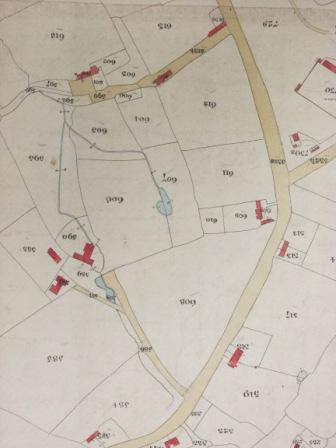
Malt Kiln Cottage, Tithe Map, 1838

Malt Kiln Cottage, Tithe Map, 1838

During this period Fish House Brook must have been much larger and more powerful to turn a water wheel. Its diminishment shows the effect of building 300 houses and their accompanying pipelines for clean water, drainage and sewage during the Central New Towns Project in the 1980’s.

Greencroft Valley

Greencroft Valley

Greencroft Valley is the largest surviving green space between the new estates. The old field lines remain intact, indicated by rows of trees. The wooded areas provide living space and nesting places for hedgehogs, squirrels and birds including magpies, wrens, a variety of tits, nut hatches and a woodpecker.

Greencroft Valley

Greencroft Valley playing field

The brook has had its share of pollution problems, mainly from grey water out of faulty washing machines. Since reporting this, it has been less frequent. Frog spawn and frogs have been seen, and a few smaller insects. However, there is no sign of any fish. This is disappointing as the 1840’s map shows a fish pond, which according to the Tithe Map was in Fish Pan Field, suggesting local people used to pan in the brook for fish.

Fish Pan Field

Fish Pond and Greencroft Valley 1840, courtesy of Mario Maps

Fish Pan Field

Greencroft Valley now, courtesy of Mario Maps

The brook is culverted from Greencroft Valley beneath Hill Road South.

Fish House Brook, Culvert under Hill Rd SouthIt emerges close to Rosefold house and cottages.

Rose Fold Cottages

Rose Fold Cottages

According to Elizabeth Basquill the cottages and yard were part of a tannery. During the late 19th century Fish House Brook was used to wash hides. ‘The hides were soaked in slaked lime first, then washed, and the hair and flesh scraped off.’ This process would have caused considerable pollution to the stream. Two adjacent fish ponds, which Elizabeth believes may have existed from the medieval period were ‘later used as tan pits for washing the skins’ (3).

Rosefold

Rose Fold 1840, Courtesy of Mario Maps

Rosefold

Rose Fold now, courtesy of Mario Maps

The first stretch of the brook, heading northeast, cannot be followed behind the houses. Where it makes a rightangle and heads northwest, a footpath runs alongside it. This follows the line of a much older route that led from Middleforth Green to St Mary’s Well (4).

Fish House BrookIt then bends right and passes through Campbell’s Park Homes following its old course round the back of the mobile houses.

Fish House Brook, Campbell's Park Homes

Fish House Brook, Campbell’s Park Homes

Campbells Park Homes, Meadows

Fish House Brook 1840, courtesy of Mario Maps

Campbell's Park Homes, Meadows

Fish House Brook, the Meadows and Campbells Park Homes now, courtesy of Mario Maps

The residential park nestles within the triangle of Penwortham Junction. The train lines pictured closed in 1965 and are now covered by beech, birch, sycamore, bramble and an array of wildflowers, forming important wildlife corridors.

Campbell's Park Homes

Campbell’s Park Homes

Another tributary enters Fish House Brook, running from the back of Far Field across the meadows. The pathway to St Mary’s Well crosses it, and there is a newer footbridge further south. At this time of year the meadows are thriving with mayflowers, buttercups, plantain, wild carrot, orange tipped and cabbage white butterflies and an abundance of bees.

The Meadows

The Meadows

The brook runs through Penwortham Allotments (unfortunately out of bounds) then is finally culverted beneath Leyland Road under Fish House Bridge.

Fish House Bridge

Fish House Bridge

Fish House Bridge

Fish House Brook culverted under Fish House Bridge

The 1840’s map shows a lodge beside Fish House Bridge. Alan Crosby says the bridge took its name from a timber building which ‘served as the quarters of the manorial river bailiff.’ This dwelling was adjacent to the fish garths, which were mainly used for catching salmon between December and August. It was the bailiff’s task to make sure the fishermen from different townships abided by the rules of the fisheries (5).

Fish House Bridge

Fish House Bridge 1840’s, courtesy of Mario Maps

Fish House Bridge

Fish House Bridge now, courtesy of Mario Maps

It is clear Fish House Brook derives its name from the Fish House, and as far as I know, no trace of an earlier name remains.

~

Each of these locations holds a story and discloses a relationship between the brook and the people who have depended on it. Since water started being piped in the 19th century, we’ve had no need to fetch it from wells or streams for drinking or bathing. Due to modern farming and production methods few of us rely on local waterways for fish, mill our own grain or tan our own skins.

This has a distancing effect. Due to continuing building work, I cannot imagine a time when the water from Fish House Brook will be safe to drink. It is uncertain whether fish will return, although some small fish were sighted by mum in nearby Penwortham Brook.

Small fish photographed by my mum in Penwortham Brook. Can you identify them?

Small fish photographed by my mum in Penwortham Brook. Can you identify them?

Whilst it’s impossible to turn back the clocks, I think there is time to get to know and understand our watercourses, and the lives and motivations of the people who have worked with and changed them. This article is an early marker stone on the journey through this process for me.

(1) Courtesy of Mario Maps
(2) Elizabeth Basquill, More Hidden Histories of Penwortham Houses (2011), p6-11, 42-44
(3) Ibid, p34-36
(4) St Mary’s Well was famous for being the cleanest source of water in the area and was attributed healing properties. Local people used to walk a mile to access their favoured water source, and it was also a site of pilgrimage.
(5) Alan Crosby, Penwortham in the Past, (1988), p48

Black Dog

He lies beneath my bed
and skrikes through the night,
plummeting the suburb into blackness.

Dampening floodlit windows,
putting out the streetlights,
he licks my hand when I am lonely.

When I fear I cannot live he takes me
to the otherside where we enter
the secret commonwealth of Middleforth

padding along the causey past the windmill’s
constant throb, cows with swaying udders
and hens clucking in the tithe barn.

Yet on communal ground
we are still invisible outcasts
with insatiable hunger and baleful breath.

Bound here by an obscure debt we pace the causey,
sniffing for dog-bones buried by the wayside
in a ritual that once had meaning on a lightless night.

Middleforth BrowMiddleforth Green, Spring Mist 007 - CopyMiddleforth Green

Castle Hill

Castle Hill, motteSegregated by the howling by-pass and enclosed within a shroud of trees Castle Hill is a well kept secret unknown to most of Penwortham’s residents. Yet this hidden headland puts the ‘pen’ in Penwortham, or Peneverdant- ‘the green hill on the water’. It is the place where the history of the township began.

Occupation of the area dates to the Neolithic Period. The construction of Preston Docks in the late nineteenth century unearthed a collection of human skulls dating from 4000BC to 800BC, the bones of auroch and red deer, a bronze age spearhead, remnants of a brushwood platform and pair of dug out canoes indicating the existence of a dwelling akin to Glastonbury Lake Village inhabited by the Setantii tribe. Following from the notion that churches are built on pagan sacred sites it is possible St Mary’s church (which is on the summit) replaced a burial mound and / or stone circle.

The sacred nature of the hill is shown by three recorded holy wells. The best known is St Mary’s Well, which was located at the hill’s foot. It was attributed healing properties and was an important sight of pilgrimage. Since drying up its has sadly been covered over by the by-pass. This well was of such importance local people walked a mile to fetch water from it, following the pilgrim’s path. St Anne’s well was located to the west of the church. A well within the church was recently discovered to contain a body inhumed with three skulls which might serve an apotraic function.

A ballista ball and nearby industrial site supplemented by the tale of a ghostly troupe of centurions suggest Roman occupation. The castle mound and its twin at Tulketh were built by Saxons to hold off the Vikings who buried the infamous Cuerdale Horde. When the Normans invaded they rebuilt the castle and Peneverdant served as administrative centre to the Barony of Bussel. The hill was also the site of Penwortham Priory and residence of some scurrilous monks.

Since then St Mary’s church has governed the parish. Whilst the earliest known grave is of a 12th C crusader, the graveyard has served as a burial place for Penwortham’s people since the sixteenth century. The war memorial on the south bank resonates deeply with its association with ancestral remembrance.

One of its darkest legends concerns a fairy funeral. Two men returning home come upon a procession of little men clad in black, wearing red caps and bearing a coffin. One of them dares to look within and sees his miniature doppelganger dead and cold. When the fairies begin the burial he tries to stop it by grasping their leader and the party vanishes. Driven mad by the experience he topples from a haystack to his untimely end.

The path running through Church Wood beside the hill is known as Fairy Lane. In spring it is covered by bluebells and ransoms. In summer the blackbird song never ends. In autumn winds crash, leaves fall and the by-pass roars. Through winter’s depth ivy keeps the wood alive, the leaning yew holds vigil and for a blessed moment there is silence.

Every visit to this magical place, standing between humanity and nature, the dead and the living reminds me of those unseen bonds which might otherwise remain unacknowledged as the old green hill.

* First published in The Druid Network Newsletter (Samhain 2013)

Spirit of the Aquifer

In eighteen eighty four
a monolithic feat of engineering
shifts the Ribble’s course:
no water to the springs.

From the hill’s abyssal deep
a rumbling of the bowels,
a vexed aquatic shriek:
no water to the wells.

Breached within the chasm
a dragon lies gasping
with a pain she cannot fathom:
no water to the springs.

Water table reft
her giving womb unswells,
surging through the clefts:
no water to the wells.

Unravelling inside
her serpent magic streams
to join the angry tides:
no water to the springs.

Culverted and banked
her serpent powers fail,
leaking dry and cracked:
no water to the wells.

The spinning dragon-girl
tumbles from her swing
and slips to the underworld:
no water to the springs.

Her spirit will not rise
through the dead and empty tunnels,
disconsolate we cry:
no water to the wells.

The hill, no longer healing
stands broken of its spell,
no water to the springs,
no water to the wells.

Peneverdant, A Lunar Cycle

I. Dark Moon

On a dark moon
the lady in the ivy
winds down the dark hill
and the falling graves.

All memory
is sliding into darkness,
the river’s tides
her open mouth.

She is waiting
for the return
of her tribe
on their oaken boats.

The moon is dark
over the river-
an eye, a maelstrom
between the worlds.

The fleet are ready,
the church is empty,
graves as hollow
as the old green hill.

She will be waiting
in the ivy
for the return
of her tribe
on their oaken boats.

II. New Moon

All is darkness
but the splash of the tide,
the wing of an owl.

Lady Ivy
recounts her losses
on the hill
and the bank
where the hangman
wore his cowl.

They are waiting
in the maelstrom eye
of the new moon-
the river’s entryway
to living day
and deep Annwn.

They are waiting,
her hidden tribe
on their oaken boats
in a slit of light,
an opening moonbeam
to row through
the night
to the old green hill.

III. Moon First Quarter

There is wisdom
in the eyes of an owl-
a demand,
a categorical imperative.

Behind cumulonimbus clouds
secretly moon’s orb
is swelling.

They row.
History is written
in their woad-
gods and goddesses,
an oak king,
the lakes and water courses
of their oaken fleet,
the moon’s eye
in the shining river
and all the laws of the deep.

IV. Full Moon

The moon is full
behind the clouds.
She casts no light
on the empty boats,
the processional route
around the old green hill,
the moving river of woad.

Lantern bearers
pass the old iron rails,
the gloomy gathering of graves
to assemble on the mound,
igniting the beacon fire.

By the wing of an owl
the clouds are moved.
The moon looks down,
victorious.

They salute her orb
in the shining river,
the gods of the hill
and the deep.

On this night
of opened graves
anything is possible
in the light of the beacon fire
before the lambent eye of the moon.

V. Moon Last Quarter

Night has fallen
from the moon’s closing eye.

The owl has flown
to the hunt.

The fire gone cold
with the lanterns’ glow
is eclipsed by street lamps
and brake lights.

The by-pass roars
by the old green hill.
The river is concreted
back in her new course.

Lady Ivy
winds down
the hill and the graves.
She waits
for the tribe to row
to the river-moon
on their oaken boats,
to her maelstrom-eye
between the worlds.

Greencroft Valley


Greencroft Valley


Greencroft Valley is located in Penwortham, and is split down its centre between Kingsfold Ward on the east and Middleforth Green to the west. From (at least) medieval times up until 1984 the valley was farmland. The 1839 Tithe map shows the fields at the south end of the valley (between Pope Lane and the old Oak) as belonging to the Mayor family, who owned Malt Kiln Farm and Cottage. The cottage was originally a water powered mill, where barley from the local fields was made into grain. Following this, grain was soaked in a stone trough, ‘chitted’, germinated, dried in a kiln and ‘riddled’ before being placed in sacks to be taken by horse and cart to the Black Bull Inn. The land was bought by the church in 1860[1].

The fields north of the Oak belonged to the Baker family, who lived in a house called Alderfield, and later became Miss Whittam’s riding school (the site is now covered by Greencroft). The old hedge line can still be seen between the old Oak, the adjacent trees and another oak tree of a similar age near the Malthouse Way entrance. Another visible hedge line divides the green from the woods close to the Maltings. This divided the fields belonging to Alderfield from Fish Pan Pasture.

The presence of the mill combined with the two fishing ponds on the Tithe Map and the large culvert adjacent to Hill Road South, all form evidence that Fish House Brook was several times larger and more forceful than it is now, showing the drastic shifts that have been brought about in the water table over the past 150 years. Another point of note is that there was a well in the valley close to the edge of the brook, to whose steps a path ran from Alderfield; this disappeared with the building of the new estates.


The large and irregular field patterns suggests they date back at least to medieval times. A 1590 map refers to the land that stretches from Pope Lane to Castle Hill as ‘all these ancient and several lands of the manor of Penwortham as well as the Queen’s as of freeholders and copyholders[2]’. The first entry for Penwortham in the Domesday book cites the existence of ‘two ploughs,’ in reference to Penwortham End and Middleforth Green. Evidence from the Dock Finds shows the area adjacent to the Ribble near Castle Hill was occupied from the Neolithic period onward. If this was the case in higher Penwortham, then judging by the population figures (the population of Britain was higher in the Iron Age than it was during the Norman period[3]) it is possible Middleforth Green and the valley have been occupied and farmed just as long.

The occupation and land use changed dramatically between 1979 and 1984 as a result of the Central Lancashire New Towns project. This was set up in 1973 and aimed to draw together Penwortham, Preston, Walton, Leyland and Chorley in a vast urban sprawl with a population of half a million, covering 55 square miles with houses[4]. During this period the estates of Greencroft, Malthouse Way, Alderfield and the Maltings were built- over 300 houses, bringing an approximate number of 600 people[5] into the area, in stark contrast to the small number who occupied Malt House Farm and Cottage and Alderfield. It was during this period that Middleforth School, which was founded in 1861 and was formerly a Chapel-School situated where Church Brook House now stands at the bottom of Marshall’s Brow, was moved to its present site[6]. It seems needless to say that the impact on the nature and wildlife of the area must have been huge.

This open green space and woodland now forms an important habitat for wildlife, a roosting place for birds, a possible swimming place for stream life and a pleasant vista for dog walkers and play area for children, and is the only place amidst the new estates where the traces of so many centuries of our rural past is preserved. Home to a plethora of living things, from those with roots and leaves, to those with legs, tails or wings, it is an eco-system that deserves care and respect, and this is the purpose of the Friends of Greencroft Valley.

[1] Elizabeth Basquill, More Hidden Histories of Penwortham Houses, (The Friends of Hurst Grange Park, 2011), p6-11, 42-44.
[2] Alan Crosby, Penwortham in the Past, (Carnegie Press, 1988), p67
[3] There were 3 million people in 700 BC compared to 2.5 million in 1086 http://www.ukagriculture.com/countryside/countryside_history.cfm
[4] Alan Crosby, Penwortham in the Past, (Carnegie Press, 1988), p145
[5] Going by the average figure of 2.32 people per household http://www.communities.gov.uk/documents/statistics/pdf/1172133.pdf
[6] Penwortham Magazine, Issue 3.